Le street art pour célébrer la Femme
- News
Positiv Media
- June 2, 2022
- 1
- 2372
- 8 minutes read
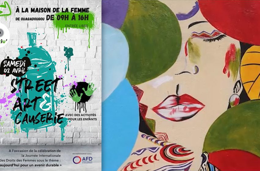
Le réseau de femmes entrepreneures Positiv’ a organisé, le 2 avril dernier à la Maison de la Femme de Ouagadougou, une causerie-débat autour d’un événement street art à l’occasion de la Journée Internationale des Droits de la Femme. Près de 200 personnes avaient fait le déplacement pour ce nouveau concept de mobilisation citoyenne en collaboration avec l’Agence Française de Développement. Un acte deux est d’ores et déjà appelé de plusieurs vœux.
Street Art & Causerie. C’est le nouveau concept initié par le réseau de femmes entrepreneures Positiv‘ à l’occasion de la Journée Internationale des Droits de la Femme sous le thème, cette année de : « L’égalité aujourd’hui pour un avenir durable ».
Avec le succès remporté, l’événement, en partenariat avec l’Agence Française de Développement (AFD), s’inscrit déjà comme une première édition. Hommes, femmes, enfants, près de 200 personnes ont répondu présents et activement participé à toutes les activités proposées.
Symbole fort, c’est sur les murs de la Maison de la Femme* de Ouagadougou que Bertine Ouédraogo, directrice de Positiv’, avait choisi de laisser s’exprimer les artistes peintres Makamssa Yago et Moussa Maïga pour une œuvre street art forte de symboles illustrant « l’égalité et un monde en commun ».
Bertine Ouedraogo explique le choix du street art par le fait vouloir « laisser une trace pérenne, dans l’espace public pour exprimer de façon artistique, imagée et accessible l’égalité femme-homme ».
Et pour faire date, elle a organisé toute une série d’activités autour de la création de l’œuvre et de la causerie pour mieux attirer et sensibiliser les Ouagalais et les Ouagalaises.
Galerie d’art au féminin et marché artisanal éphémère, buvette, body painting, Positiv’ a même organisé des ateliers de peinture pour les enfants afin que les parents puissent sereinement venir assister aux rencontres.
Pour Anne-Marie Sawadogo, née Zouré, qui représentait l’AFD, l’AFD ne pouvait qu’être séduite par l’approche artistique proposée parce qu’elle « s’investit fortement pour le renforcement du lien social, à travers notamment le genre, les industries culturelles et créatives, le sport et le développement ».
Et le fait que l’art mural soit réalisé à la Maison de la Femme et sur les murs d’une salle de formation résonne totalement avec « l’autonomisation économique des femmes : un des axes prioritaires de la stratégie d’intervention de l’AFD dans la région du Grand Sahel (Burkina Faso, Mauritanie, Niger, Tchad et Sénégal) ».
La chargée de mission régionale trouve « formidable » le fait d’utiliser l’art « ce langage universel pour exprimer un sujet délicat ».
Et ce langage, l’événement aura aussi pu laisser les gens s’exprimer, notamment à travers un mur d’expression artistique, symbolisé par un arbre où chacun était invité à laisser sa propre œuvre pour illustrer le thème.
Et l’on voit, comme dans l’exemple ci-dessous, toute la puissance des imaginaires.
Le street art a servi d’outil de dialogue et d’échange, mais aussi de prétexte, pour nourrir l’autre versant de l’événement : la causerie.
Et des échanges il y a en a eu. Beaucoup. Ils étaient riches, riches de la diversité des participants. Beaucoup de jeunes ont pris la parole, des hommes et des femmes ont témoigné, se sont ouverts même, pour explorer ensemble la question du genre.
Avec parfois des approches plus inclusives qu’on pourrait le penser, comme ce participant qui estime que « tout ce qu’on fait pour moi, sans moi, est contre moi ».
Il faut donc « intégrer les hommes et les jeunes garçons pour qu’ils apprennent le concept du genre dès le bas âge » pour que « ça ne soit pas demain un combat mais une réalité ».
« On ne vas plus perdre le temps à faire des foires, des ateliers, des conférences publiques, des débats autour de la question du genre, mais on implémentera des actions ».
Pour Paule Elise Henry, cheffe de projet Fonds Genre Sahel à Expertise France, « C’était vraiment un moment de joie, de partages, d’expériences et d’enrichissement mutuel ». Elle retient que « c’est l’éducation à la base qui est vraiment le socle du changement ». Elle estime, à l’issue de la journée que « les déclics sont là ».
Apprendre en s’amusant et être acteur du changement. Les méthodes ludiques d’animation de la causerie se sont appuyées sur des exercices d’intelligence collective. Avec un jeu du « Vrai ou Faux » pour déconstruire des idées reçues, avec des mémos d’astuces pour prodiguer des conseils aux parents, avec des invitations à s’engager tirées au sort pour chacun.
« J’ai trouvé le débat de haut niveau sur la question du genre, avec beaucoup d’interventions de jeunes qui touchaient au réel. Certains étaient émouvants », relate pour sa part Hervé Kahane, chargé de mission à la direction régionale Grand Sahel de l’AFD.
Il retient de la journée que le combat pour l’égalité passe par l’éducation. « Les choses se perpétuent de génération en génération et à la fin ça devient naturel » et loue toute la scénarisation de l’événement. Il espère, comme bien beaucoup, « qu’il y en aura d’autres les années suivantes ».
« Je voulais que l’événement soit une fête utile et je suis plus que satisfaite », déclare Bertine Ouédraogo qui tient à remercier toute son équipe. Une fête utile « que je voulais aussi génératrice de revenus pour toutes les exposantes invitées ».
Et aussi une fête solidaire, car Positiv’ a ménagé une place à la vente de bijoux pour soutenir les populations déplacées internes. Et même passé directement commande pour pouvoir offrir des lots aux participants de la journée.
L’écho de Street Art & Causerie ne s’est pas cantonné aux seules personnes présentent. Il a eu les honneurs de la presse et de la télévision, avec notamment un reportage complet dans le journal de la chaine BF1 TV.
Un impact donc national pour l’événement et des graines partout semées dans les esprits.
“*La Maison de la Femme est un centre multiservices de promotion de la femme qui permet aux femmes d’avoir en un seul lieu, l’accès aux informations utiles dans plusieurs domaines clés pour leur autonomisation. Le centre offre aussi des services directs de formation et d’assistance aux femmes dans des domaines tels que l’alphabétisation, l’entrepreneuriat, la prévention et la gestion de la violence basée sur le genre.”


1 Comment
Un super événement avec l’art comme vecteur…